
Journey of the Moorabool River
Words and Images By Alison Pouliot
The swampy origins of the Moorabool River
Sources of water have provided interest and intrigue to people across cultures throughout history. Besides the obvious necessity for potable water, many cultures also have an inherent energetic or spiritual connection with it. Water sources also represent places containing some of the most intact catchments, highest water quality and environmental values.
One such place is the Wombat Forest on the Great Dividing Range and it is the origin of seven rivers. The region has a long history of attracting people from the original indigenous people through to the various waves of European and Chinese settlers and more recently, the tree-changers and spa seekers.
One of these rivers, The Moorabool, rises in the Wombat State Forest as two branches, which meet north of Morrisons, draining an area of nearly 2,300 square kilometers. The river flows southwards through a mixture of eroded sedimentary and fertile volcanic soils and across the flat western basalt plain to its confluence with the Barwon River.
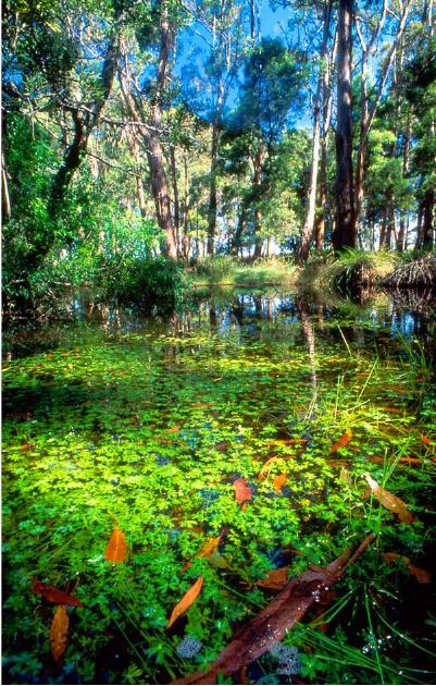
The original wetlands and riparian woodlands of the Moorabool's headwaters and upper catchment were once dominated by swamp gums (Eucalyptus ovata), manna gums (Eucalyptus viminalis) and blackwoods (Acacia melanoxylon). A few remnant tracts still remain (see image 1). However, as one wanders a little downstream, the condition of the river, the riparian area and overall catchment rapidly deteriorates. Here the river traverses a worn and parched landscape, laid desolate largely through human exploitation. The sparkling gurgling headwaters, sounds of bird and frog calls, and shady riparian areas, sadly, largely disappear (see image 2).
European settlement has led to dramatic modification of substantial areas of the Moorabool River catchment, with most of it having being intensively cleared for agriculture (see image 3). The so-called early river 'management' and 'improvement' projects saw the removal of woody debris (which serves as vital aquatic habitat), channelization and damming of the river for agriculture and urban development all of which contributed to the river's degradation. Only part of its Wombat Forest-sheltered headwaters and a few restricted reaches (e.g. between Lal Lal reservoir and Sheoaks Weir) have retained some of their environmental values. The river is considered one of the most severely flow stressed waterways in the state, flowing at less than three percent of its average rate last winter.
Further downstream the river traverses a fully agricultural catchment which was once a mosaic floodplain of grasslands, billabongs and red gum (Eucalyptus camaldulensis) forests. Fortunately some fairly intact areas of remnant grasslands still exist. In some reaches the river features a series of billabongs which provide important native fish and platypus habitat. However, flow stress resulting from water diversion further upriver has had dire impacts on the lower reaches. At the end of its journey the Moorabool River disappears beneath the concrete landscape of Geelong, out of sight and largely out of mind, where it enters the Barwon River totally unrecognizable from its origins.
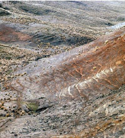
Image 2: The Moorabool's severely modified catchment
The river's journey and story are not dissimilar to those of many rivers throughout the state, the country, indeed the world. However the old adage is true that we can't judge the mistakes of history with today's eyes. Rather, we must use the understanding and great wealth of information now available to act in attempt to repair past errors.