
At long last the Lerdy flows again
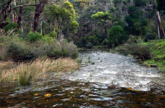
Intact riparian vegetation in the Lerderderg’s upper reaches (photo © Alison Pouliot)
Daybreak is a magical time to crawl through the damp undergrowth of the Lerderderg River. The first shafts of sunlight slice through the trees, illuminating unfurling fern fronds and a large native slug cruising the forest floor. This time a year ago the riverbed was parched and dusty, not a trickle of water in sight. Walking along it was slow progress, about a kilometre an hour, clambering over log jams and boulders crackling and crusted with dried lichens. But following the rains the river is once again swollen and teeming with life. Spiders span the river with their webs and lie in wait for emerging insects. Kookaburras laugh in synchrony across the valley and inevitably put a smile on my face. I could think of worse ways to start one’s morning. This is the Lerderderg River, known locally as ‘The Lerdy’, rising in the Wombat Forest on the Great Dividing Range. It’s a very special river. It’s also one of Victoria’s eighteen Heritage Rivers and the only one of the six major rivers rising in the Wombat Forest with this designation. Heritage rivers are protected under the Heritage Rivers Act 1992 (Vic) for their high conservation, recreation or cultural values. Part of the river is also classified as a Representative River due to its significant geomorphic and hydrologic features.
From its source the Lerderderg flows through the Wombat Forest into the adjoining Lerderderg State Park and through the Lerderderg Gorge – a spectacular 300 metre deep gorge of sandstone and slate, reflecting its 500 million year geological history. The exposed rocks at the southern end of the gorge are of international significance as they show evidence of being covered by glaciers during the Permian, about 280 million years ago (Rosengren 1988).
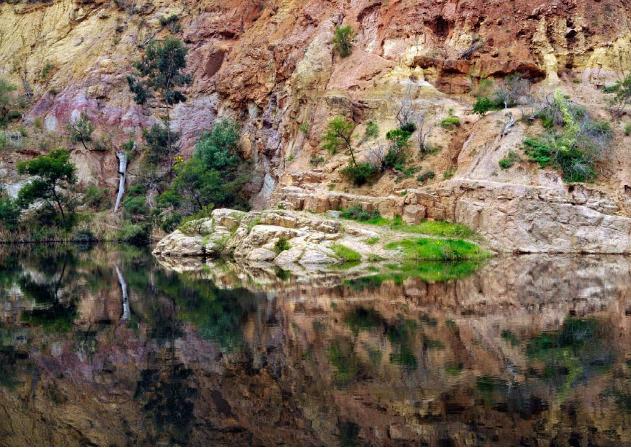
Sandstone cliffs at McKenzie’s Flat in the Lerderderg’s lower reaches (photo © Alison Pouliot)
Vegetation in the Park varies along a longitudinal rainfall gradient with damp messmate-peppermint gum forests in the north, drier stringybark-box forests near the gorge mouth and box-ironbark woodlands along the southern ridges. There are also riparian blue gum and manna gum communities of state significance. Together the Wombat and Lerderderg forests are critical habitat for a diversity of biota as they represent the largest and most varied of the remaining isolated forests scattered through north-central Victoria (Parks Victoria 1999).
Brilliant blue damselflies are already up and on the hunt, deftly hovering and darting just above the water surface. The waking forest resonates with buzzing insects and the splash of fish in pursuit. Six native fish species including mountain galaxias and blackfish live in the upper reaches. The quiet explorer may encounter all sorts of mammals including wombats, echidnas, eastern grey kangaroos, swamp wallabies, ringtail possums, bent-wing bats or perhaps even a greater glider. The rocky ridges and patches of old growth provide important habitat for raptors including wedge-tailed eagles, Peregrine falcons, powerful owls and barking owls.
The Lerderderg’s 63km journey ends on the basaltic plains of the Werribee Valley where it joins the Werribee River at Bacchus Marsh. Its short but significant journey is a reminder of the need for improved protection against the myriad of threats that could compromise this very special river’s ecological integrity, especially in the headwaters in the Wombat Forest. As I scramble across the river my old boots clamber for purchase on precariously slippery rocks. But if I fall in, what the heck. They’ve been a long time dusty.
References
Parks Victoria 1999 http://www.parkweb.vic.gov.au/resources07/07_0251.pdf
Rosengren, N.J. 1988 Sites of Geological and Geomorphological Significance in the Western Region of Melbourne, Department of Geography, University of Melbourne, Melbourne.